| Research Divisions | |
| Research Progress | |
| Research Programs |
| Location: Home>Research>Research Programs |
| Research Programs |
|
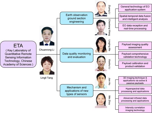
The Earth Observation Technology Application Department (ETA) of the Academy of Opto-Electronics (AOE), Chinese Academy of Sciences (CAS), was established in 2005 and formerly named as the Sky-to-Earth Integration Remote Sensing System Laboratory of General Technologies. In August 2014, ETA successfully applied to be the Key Laboratory of Quantitative Remote Sensing Information Technology of CAS. 1. Research fields ETA mainly focuses on the development of spaceborne/airborne earth observation (EO) technology, enhances application-oriented system engineering technology, and promotes the seamless integration of engineering technology and remote sensing applications. To meet the requirements of meaningful earth observation and quantitative applications, ETA also carries out research on earth observation data quality evaluation/validation, and on mechanism/applications of new types of sensors, to improve capability and reliability of earth observation mission’s outputs.
Fig.1 Main research fields of ETA and academic leaders of the team 2. Development targets The development targets of ETA are: (1) To undertake general tasks in national systematic/complex projects, play an important role in national earth observation key project plans, continuously improve the systematic design capability in dealing with complicated system, achieve valuable scientific outputs, and become an important engineering force in China in the field of earth observation technology and applications. (2) To carry out scientific research on remote sensing data processing and application technology based on sensor characteristics, obtain outstanding achievements on both sensor performance analysis and data processing techniques, construct a national key laboratory devoted to application-oriented mechanism analysis and comprehensive validation for advanced sensors, forge a high level technical team and become an important data quality assurance center for national earth observation missions. 3. Achievements Since the establishment of ETA, it has undertaken a number of projects from various research grants, including National 863 Program (National High-tech R&D Program), National Key Technology R&D Program, National Science and Technology Major Project, National Natural Science Foundation of China, etc. Especially, the national 863 key project, "UAV-based remote sensing payload pre-launch calibration and validation system", has been entitled the Excellent Team Awards of the "11th Five-Year" National Sci & Tech Program by the Ministry of Science and Technology of China. Moreover, ETA has also received the Advanced Collective Awards for Sci & Tech Achievements in China's "11th Five-Year" period. More than 240 papers have been published with over 90 papers cited by SCI/EI, and 3 academic monographs will be issued soon. Three patents and 19 sets of software copyright have been granted, and 15 patents are in processing. 4. Other work (1) Secretariat of SAC/TC327 The National Technical Committee 327 on Remote Sensing of Standardization Administration of China (SAC/TC327) was established in March 2008, approved by the Standardization Administration of China (SAC). It is responsible for the national standardization work of the whole remote sensing domain in China, which covers remote sensor development, data transmission and reception, data archiving and dissemination, data processing and its products, calibration and validation, data management and services, remote sensing experiments and applications, etc. As the undertaking unit of the secretariat of SAC/TC327, ETA is in charge of the routine work of the committee, and keeps close contact with relevant S&T institutes to effectively advance the standardization of remote sensing technology in China. Up to October 2014, there are 10 items of specifications having been listed in the national standard developing program (three issued within them), and more than 20 items under review. (2) China Space Application Center for Disaster Reduction The China Space Application Center for Disaster Reduction was jointly founded by the National Disaster Reduction Center of China (NDRCC) and AOE in May 2006. ETA is the technical research unit of the center. ETA has assisted NDRCC to accomplish design and development of the ground section of HJ-1 constellation, undertaken projects such as "Operational management software system for HJ-1", "Operational management subsystem for disaster reduction applications" and "Generation and visualization of multi-satellite & multi-payload observation scheme in disaster response". These projects' achievements provide strong support to the applications of national satellite data for disaster reduction. (3) Earth Observation Data Center for Emergency Response To improve the application ability of Chinese earth observation infrastructure for disaster reduction, the "National coordination system & data sharing service platform for spatial data acquisition, application & emergency response", also known as the "Reservoir emergency response platform", was developed under the grant of the Ministry of Science and Technology (MOST) of China. The platform provides functions to coordinate various civil aerospace resources to acquire remote sensing images of the stricken area, and disseminate the data to relevant institutions involved in disaster reduction as soon as possible. ETA acts as the "Earth Observation Data Center for Emergency Response", which is the core supporting unit of the platform, playing an important role in spatial data sharing of emergency response for Yushu earthquake (Omi, China), Lushan earthquake (Sichuan, China), Ya'an earthquake (Sichuan, China), etc. |